Taeke Harkema | Portfolio

Portfolio

Linealytics, perception and identity

In search of an identity for Rotterdam

Architecture and the city are intimately associated with each other, because the city provides context for most architectural endeavours. To understand the city means to understand the conditions of architecture. Moreover, architecture in the city has as a primary objective to accommodate public life. Therefore, architectural research has, naturally, to investigate the complex relationship between public life, architecture and the city.

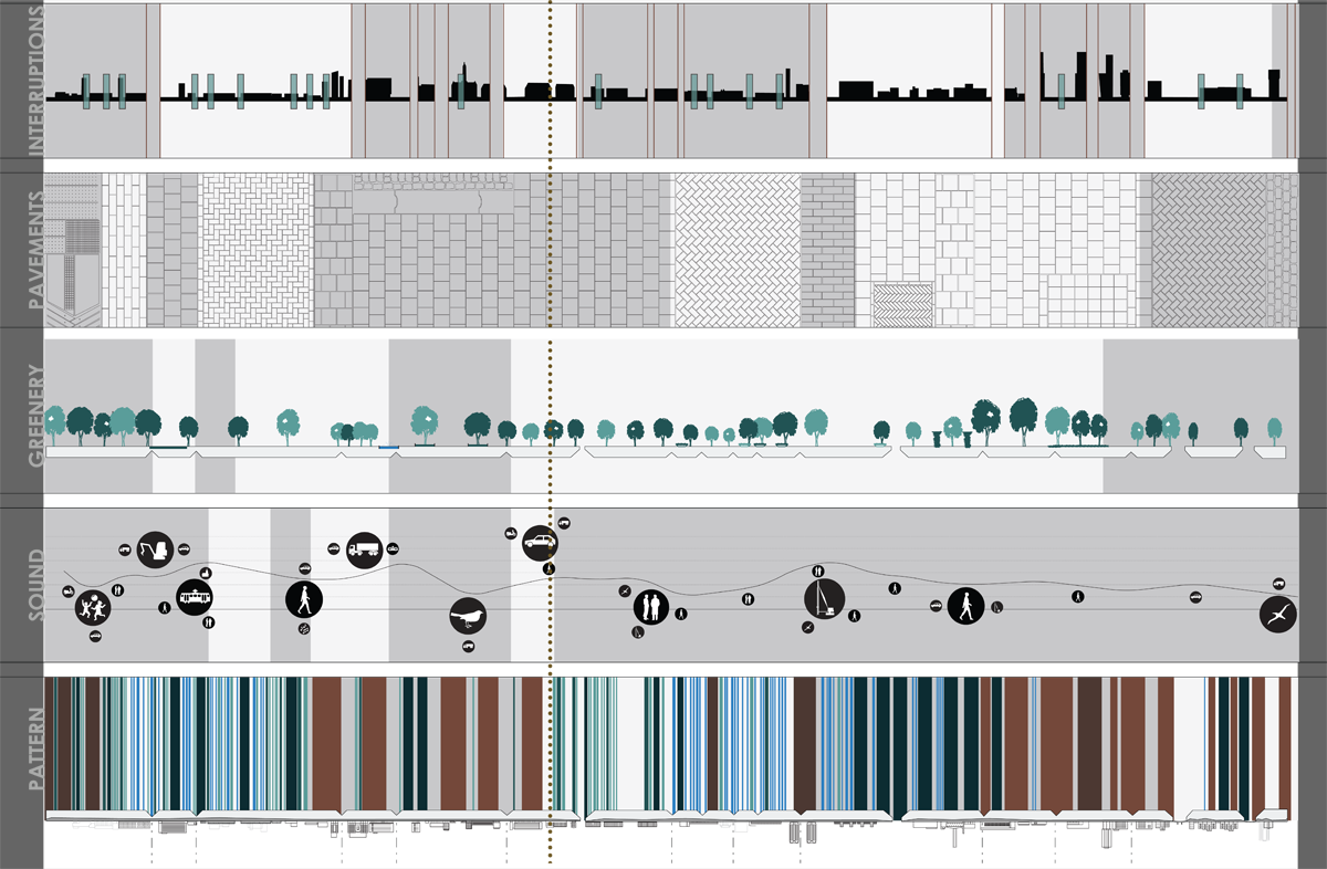
But not just the architectural form is responsible for the collective experience of the city. Trees, sounds and pavements, perhaps even personal encounters and specific smells, all contribute to our experience of an urban environment. Our memory of its specific moments helps to identify different surroundings, even different cities. Neither of the senses works alone, nor does our imagination perceive in parts. Rather, the qualities of different senses together provide us with a coherent feeling which we record in our memory.

With this research project, we ask a broad question: how do we perceive the city? The question asks for an approach of the city with an open mind, discussing its characteristics as they might be perceived by anyone who strolls through its streets, but more importantly, the question also pursues a coherent view of what the city means in general. The question holds a fundamental problem, too: the image of a city as a single, coherent, monolithic entity does not immediately and intuitively respond to the modern complexity of the movements and activities going on in a city. This reflects in our analysis. Different characteristics, such as culture, mass shopping areas, a waterfront or dwelling, contribute to the cognition of a city, all contributing their bit to the continuous whole we perceive as a city.

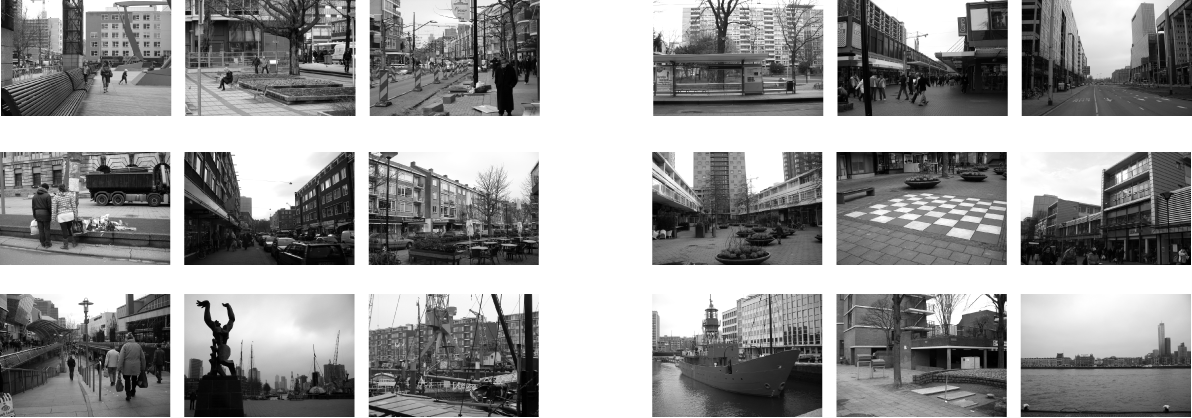
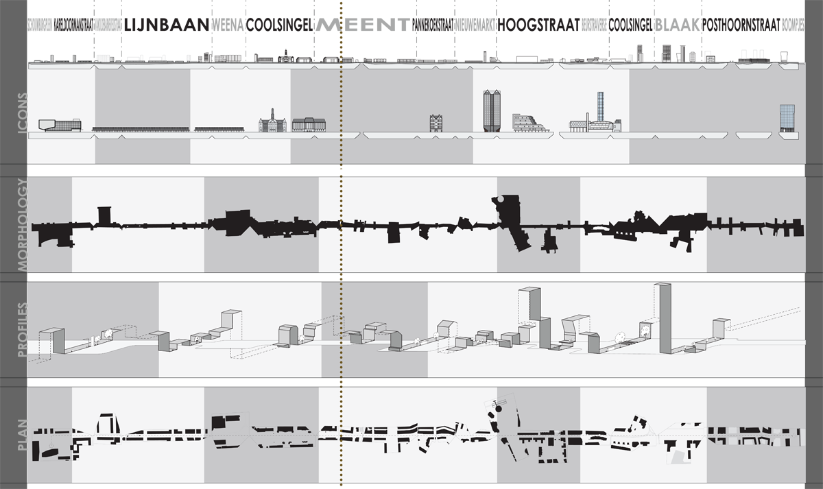
Especially in Rotterdam, the problem of fragmented identity is pressing, as the continuous and evolutionary development of the city centre was brutally disrupted by the bombings of the second World War. The redevelopment schemes of Van Traa, first issued in 1946, divide the city in functional zones with a predefined characteristic. The plan has received a lot of criticism from its conception, that pointed out the lack of quality that is perceived “in between” the designated areas of the scheme. According to this criticism, the simplicity represented in the functional zoning cannot properly answer to the complexities of a city. The characteristics of the different zones, however, are real enough for an unsuspecting visitor: the Lijnbaan appears as the heart of the commercial zone, the Schouwburgplein as a cultural heart. We have taken the idea of predefined characteristics as a first hint to a description of the identity of Rotterdam. The city centre, at first sight, harbours five distinctly characterized areas:

  1. the Schouwburgplein has a cultural character;
  2. the Lijnbaan houses mass commercialization;
  3. the Coolsingel administers representative powers;
  4. to the east, such streets as the Pannekoekstraat and the Nieuwmarkt are conceived as dwelling areas;
  5. and finally in the harbour zone the water prevails.

Identity of Rotterdam

From left to right, from top to bottom: a route through Rotterdam in snapshots

When we ask what the identity of Rotterdam is, we search for shared and continuous aspects among these areas, but we do not want to limit our search on forehand to these areas. Therefore, we have searched for those streets that connect the five areas with each other. Whereas the areas line up primarily in a north - south direction, the streets interconnecting them (the main traffic arteries of the city: Weena, Blaak; but also less articulated, slow speed connectors such as the Meent and Hoogstraat) orientate east - west.

From the Schouwburgplein to the harbour, Rotterdam reveals far more traits than the five suggested areas, with less clear boundaries. The snapshot photos guide us through eighteen particular moments in Rotterdam, showing more peculiar uses and more complex behaviour in the city. The snapshots document the ity in transit, with all its different faces at varying places and in varying times. Here, we can get a primordial grasp of what the city contains, what it lives up to, or what potential it has to offer.

The benches on the Schouwburgplein invite children to play, while those in the Karel Doormanstraat offer space for retreat. At the same time, this street shows a familiar sight in the city: ongoing construction work to improve the traffic conditions in the city. Away from the main road, we pass the tramlines to disappear in the crowds of the Lijnbaan shopping area.

We leave the shopping street on its north side, at the Weena, to turn right, passing along big office complexes towering above the ongoing traffic flows. But even there, to the side of the Coolsingel, there is space for personal loss and mourning over an accident.

Turning left again, away from the Coolsingel, we immerse in the chic Meent, where sidewalk cafés and luxury stores take turns to attract visitor’s attention. At the end, we enter the comfortable terraces of the Pannekoekstraat, and, a bit further on, the quiet businesses at the Nieuwmarkt. But just as we pass the library and cross the Binnenrotte, the rush of the Hoogstraat brings us back to the crowded streets of the centre, fulminating, finally, in the commercial hot-spot of the Koopgoot.

A left turn onto the Coolsingel leads us to the harbour area, where Ossid Zadkine’s “The Destroyed City” brings the devastating past into memory. Yet next to the old wharf cranes we find new housing projects, side by side to neglected memorials of water activity. Here, the past of the city becomes almost tangible, although the new housing projects firmly direct the city to a new chapter in its history.

Analysis

The route unfolded

The route unfolded

The route described in the snapshot images of the last pages runs crisscross through the centre of Rotterdam. It passes through certain areas which were noted a forehand to contain characteristic qualities, but it also passes through areas with no such indicators. It does, in short, wander around the centre. The route does not aim to be an existing route that city users could or would take, but covers the main street elements and pragmatic city functions. The experience and perception of the city will always take place in a small fragment of our described route.

The outcome of our analysis can be seen as an overall view of the interpretation of different users, moments and spheres in the existing city, as a chain of slices. In the schemes above the route is gradually lifted up from its urban context and unfolded to become a linear entity which transects the entire city centre. In one glance, the centre can be perceived, from the Schouwburgplein on the left to the harbour area on the right. This step in our analysis method provides the chance to observe the experience of the city in a comparative way that can be seen as a starting point for a reinterpretation with a clear input from informative layers.

The route unfolded

The representation of the city centre in a line allows for a comparative analysis via different approaches, or aspects of the city fabric. Rather than looking at the city in a faint attempt to see it as it is, we have selected multiple aspects based on how the city might be perceived. As we consider all senses important for the experience of the city, the research aspects eclipse not only form and fragment, but also touch and sound. Ultimately, all aspects present different considerations of urban understanding: they reveal issues of continuity and discontinuity through the city. The information in each separate line is represented in an abstract way based on clear reductive tools: the specific and the zonal. Aspects can be compared “along the line”, that is in relation to other places in the city centre, or across lines, so that a qualitative analysis of one specific area arises. This quantitative and qualitative analysis of several juxtaposed aspects forms a multi-layered view on the city itself.